Big kid on the little waterslide....
The Cairns Botanic Gardens were an unexpected delight, filled with big boisterous tropical plants. Jumbo sized leaves blocked out the sun, creating a pleasant way to spend a hot afternoon.


Cairn's Botanic Gardens
Next door to the gardens is the Tank Art Centre. Used to store fuel during WWII, these massive storage tanks are now used to house an art gallery and artists retreat. The works on display could have been painted by a two year old, but the islander artefacts were engrossing.

Tank Art Gallery
Our home packed up, it was time to head up the mountain range, taking the inland road to Cooktown. Leaving the Wet Tropics behind we hit Savannah country. The air was drier and cooler, the tropical plants replaced with gum trees, yellow grasses and intermittently spaced with lily filled wetlands. We were back to the familiar countryside we love, the typical Aussie bush, only with green hills dotting the background. However, all too soon again, we had to head back towards the coast and our destination. The approach into Cooktown is nothing to write home about, until you reach Black Mountain.

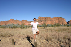
Black Mountain, near Cooktown
This dark, brooding mountain is formed by giant piles of black granite boulders, with no real plant life covering its sides. During times of extreme heat (and boy is it hot up here), the boulders explode. The noise is enough to frighten the toughest traveller. Pilots have also encountered electronic disruptions as they fly over, making Black Mountain one eerie, but awesome place.
Cooktown, situated on the Lower Cape York is a surprising, neat and tidy, yet historical town. An oasis after travelling over 300 kilometres through the outback bush. The main street is dotted with well maintained original buildings from its humble beginnings in the late 1800’s, interspersed with new sympathetic designed shops and services. The foreshore is lined with a grassy park containing more monuments than anywhere else in Australia.

Captain James Cook
I guess no wonder though- Cooktown is one of Australia’s most historically significant towns. It was here in 1770, that Lieutenant James Cook beached his ship, the Endeavour.
Atop Grassy Hill, were Cook climbed several times to view the surrounding reefs in order to navigate a safe passage out once his ship was repaired, is the site of the first kangaroo sighting by a European. This ‘creature’ was described as a greyhound like animal, which seems to bounce. I can see the similarity. Today the view from Grassy Hill has not changed much.

The view from Grassy Hill
Overlooking the twists and turns of the Endeavour River and Mount Cook the only difference is the town nestled in between.
The road into Cooktown from Cairns was only tared a few years back. The region is unspoilt, however even the Queen has been here! Back in 1970 she arrived to officially open the Captain Cook Museum. Steps made in order for the Queen to safely disembark her ship still remain jutting out from the foreshore, now leading to nowhere.

The Queen's Steps
The Museum is housed in the old Convent of the Sisters of Mercy. From the tiny Nun’s quarters, located on the second floor, French doors open onto a large balcony. A breeze would have provided sweet relief from the oppressive heat, but the view would have put their vows of poverty into question. Carving its way through the hills, thick with dark green vegetation the Endeavour River shimmers in the sunlight, its banks a creamy coloured sand. The Museum is well worth a visit- a monument to the history of the indigenous peoples as well as Cook and the gold rush days of the 1870’s. Discarded by Cook in order to lighten the load of his damaged ship, the original anchor and a canon were salvaged from the Barrier Reef and are now housed along with excerpts from his diaries.

Original anchor from the Endeavour
The Great Diving Range, familiar to us from home, carves its path all the way to the tip of Australia. We are now in the dry season, yet the sun is bold, no mistaking it is out. The heat is fierce, yet we do not sweat as much, due to the lower humidity. However, it is still energy zapping, especially after a bushwalk. Now making our way to the ‘tip of Australia’ we are travelling through hostile countryside and very ‘small’ townships. Laura, the first settlement since leaving Cooktown, is no more than a roadhouse, pub, general store and a couple of houses. There is really nothing out here, but that is why we feel so serene.

Old Police Lockup, Laura. Once held 18 men...
The ‘nothingness’ has an air of no expectations and with no phone reception; it is just a blanket of calm. Aboriginals have lived, and continue to live, in this area for thousands of years. Rock art is dominant in the hills and we were fortunate to discover some near Laura, at the Quinkan Rock Art site. Where water and food is plentiful, the art is of a superior quality. Less time in search of sustenance allowed more time devoted to art pursuits.
After a long, weary drive it was time to pitch our tent for the night in Coen (we have left our camper in Cooktown, and will be ‘slumming’ in our tent for our Cape York Adventure). Another one pub town, after setting up home, we wandered over for ‘one drink’. After all it is not every day you get to drink at the ‘Sexchange Hotel’. After befriending some local aboriginal ladies our one drink turned into a long night. However, we made some new friends and discussed the intricacies of living between two cultures.

The Sexchange Hotel, Coen
The bitumen was long gone, the red dirt road snaking its way through pencil thin trees with green bushy tops. Headed for Weipa, we had to cross a few creeks. The prettiest creeks we have ever seen. White sandy beaches and river beds line the lazy curves of the rivers, which are dotted with painted gum trees.
Weipa is home to the world’s largest bauxite (aluminium) mine, but still only a town of 3,500 people. Mine workers come from near and far and it is a young town. Perhaps this is why the vast cemetery only has one person in it! Such a strange sight.

Weipa Cemetery... only one person
However, home for us was on the grassy bank of Albatross Bay, a picturesque spot, but with deadly waters. Shine a torch at night and the eyes of the saltwater crocodiles glare back at you, watching your every move.

View from our tent, Weipa
As we head further north the temperature rises, most days hovering around the 33 degree mark. Overnight the temperature drops to 26, however a constant south-easterly allows us a comfortable sleep on our blow up mattress. We are quite content up here, although we would not survive the constant year round heat. It is a desolate area of Australia, yet with an abundance of nature. As we drove the lonely roads, we were entertained by a dingo pup bounding in our path, a hawk catching a whip snake, a blue winged kookaburra who persisted in sitting in the middle of the road, making us drive around him (no he was not dead), and the Palm Cockatoo- only found in Cape York. The Palm Cockatoo is similar to a Black Cockatoo, only slimmer and with prominent red cheeks.
The dusty dirt road led us to Bramwell Roadhouse, where the infamous Telegraph Track begins. We do not have all the safety gear required for this track, such as a winch and snorkel for our ute. Secretly I am pleased. The track is one of the roughest 4WD routes in Australia, with many deep creek crossings.

Dave checking the first creek crossing, Telegraph Track
We are able to do part of the Telegraph Track, but will mostly stick to the (still dirt) Development Road. Still corrugated in parts the Development Road is a far more ‘luxurious’ way to travel to the tip of Australia. However, to see some of the sights of the Cape, we had to ‘do the Telegraph’.
Off the Development Road it was, navigating our way through our first deep creek, and having our bonnet washed in the process we arrived at our camp for the night- Eliot Falls.

Cooling off at Twin Falls (near Eliot Falls)
Water is abundant here, the high annual rainfall of the wet season collects in the shallow sandstone bedrock and seeps into the streams year round. This continuous flow of water has carved deep channels, broken by some unique waterfalls. The falls do not drop far, but are some of the prettiest to date. However, the beauty of these falls is that they are a safe place to swim and where we spent a great deal of time escaping the heat.

Our campsite, Eliot Falls
Nearby, Fruit Bat Falls, with its Pitcher Plant lined banks was a natural spa bath, the water clear and so inviting.

Dave hiding behind Fruit Bat Falls

The main river up here is the Jardine, and to cross it we needed to hop on the barge. The crossing only takes a minute but costs $88 return.

Jardine River Ferry
But this gains us entry into Aboriginal land, and our next stop- Seisia. Are we still in Australia? This land feels like a tropical island. The locals looking more islander, the blue waters lined by palm trees and white sandy beaches. It has a lazy feel, but we were feeling a little luxurious. Our waterfront campsite came complete with a basic beach shade hut. It is hotter here than experienced before, but the ocean breeze cools our sunset drinks.

Writing this blog, from our beach hut in Seisia. Our tent in background.

Sunset at Seisia
We were only 30 kilometres from ‘the tip’, but also a short boat ride away from Thursday Island. Setting our alarm for the 7.30am departure, we boarded the charter boat from Seisia Wharf and headed out for a day’s adventure. The boat headed for Possession Island. The island is unspoilt, but rich in history. A lonely marker sits on the spot were Captain Cook took possession of Australia.

Possession Island, Cairn marks the spot Cook made a claim for this land
The island remains mostly unchanged since this time- a memento of how perilous Cooks voyage really was. As the ocean spray cooled us down we headed for Horn Island.

Welcome to Horn Island
The island is small, with limited facilities, but it featured heavily during WWII as a military air base. A tour through the local museum gave us an insight into this era, including original Japanese documents relating to the invasion of Australia, as well as the perils of the early pearling days.
However, Thursday Island, or TI as it is known was our main destination for the day. The island is small, with no real tourist development.

Thursday Island Foreshore
It is this authenticity and history, which makes the day such an insight into the lives of the Torres Strait people. Our captain arranged a local taxi driver to take us on a tour of the island. Dirk, a third generation local was proud to show us his island, including the Green Hill Fort built for a potential Russian attack after the Crimean War.

Green Hill Fort

Main street, Thursday Island
However, the highlight of the day was the trip back and a spot of fishing. We have not caught one fish during our 19 months on the road, but the drought has been broken. Within seconds of casting a line, Dave had caught the first fish- a Queenfish.

Dave's catch!
I pulled up the second- a Golden Trevally. It was not the biggest Trevally caught on the day, but we feasted on our catch (filleted by our Captain) over a campfire with our neighbours.

My catch!
After the dehydrated foods consumed to date the sweet, melt in your mouth fish was a taste sensation.
But, we were itching to plant our feet on the most northern tip of Australia.

The Croc Tent- souvenir tent on the way to 'The Tip'
A well groomed red dirt road led us as far as we could drive. Then it was a 10 minute walk to the ‘tip’. As we strolled over rock gazing out to the azure blue waters, we soon ran out of land. A sign confirmed we had reached the spot. This was it.

Made it! Standing on the tip of Australia
We had now been to all the compass points of Australia- the most Northerly, Southerly, Westerly and Easterly. There really is not much more of Australia left for us to explore, but we will take a few months yet to make our way back to Sydney.
We did not know what to expect of the land up here. It is a mixture of savannah, thick tropical bush, scrub and all manner of ant hills. Even in the dry season there is still moisture in the air, making it one hot place to be. I do not know how early settlers survived here, but back in the late 1800’s nearby Sommerset was were the Jardine’s called home. The Grandson sold the settlement to the government in the 1940’s and now all that remains is the old well, windmill and the lonely graves of the real ‘last pioneers’.

Lonely graves of the Jardines
This region was an important military base during WWII; however it was the most notorious. Many lives were lost trying to land or navigate the harsh environment. Two plane wrecks still remain as a vivid reminder of how perilous this region is. A DC3 lies in scrub, torn apart by the force of impact, her remains scattered far.

Plane wreck near Seisia
We had three nights at Seisia, allowing us to soak up the sights of the Northern Peninsula Area of Cape York. However, after an uneventful first two nights, we had a sleepless third. We were in croc country, but were yet to sight the elusive creature. All this changed on the afternoon of day three. Cruising up and down the waters, we judged his length at 4 metres. As the tide rolled in, so did Mr Croc. By nightfall the water was about 50 metres from our tent, with Mr Croc hovering at the shore line. We listened to all the safety advice and consequently lived to tell the tale!

Mr Croc in foreground of pic
We were glad to be moving south, even if it meant trudging down the Telegraph Track to see the Gunshot Creek crossing- the most infamous of them all. The Telegraph Track was built in the 1880’s to facilitate the telegraph line from Cairns to Thursday Island. Constant maintenance was needed, so camps were set up along the line, which still accommodate us weary travellers today. The last message was sent along the line in 1962; the track remained and is now one of the greatest 4WD challenges.
There is no way I will ever do ‘Gunshot’. The entrance to the creek is a steep 5 metres drop into muddy water. Once in the creek you have to navigate large holes before emerging up another steep embankment. Too scary for me.

Gunshot creek crossing- Dave at the bottom of entry/ exit
Gunshot often ‘wins’ and many car parts are nailed to the surrounding trees. You can camp on the banks surrounding Gunshot- a must for some people, who have to wait for engines and cars to dry out before proceeding further along the Telegraph.
Musgrave Station was one of the stations built in 1886 to service the telegraph line and was where we spent our last night. A full moon shed its silver light over the countryside and we reflected on our visit into the last remaining outpost that is Cape York. As we headed south the weather cooled each day. It was amazing the change since we headed north 10 days before. The ‘pretty’ creeks were drying up, becoming muddy brown. The green scrub lining the roads now covered in thick red dirt, flicked up by passing cars. The freshly graded road, that gave us a smooth ride on the way up, was now churned up.
We were glad to have seen the area just after the wet, while she was fresh and alive. However, it did mean some fast flowing creek crossings and closed roads. We were not able to access Iron Range National Park, with Australia’s largest lowland rainforest.
Before bedding down in our comfy camper for the night back in Cooktown, we took one last detour through Lakefield National Park.

Old Laura Homestead
The Old Laura Homestead has been reconstructed- an example of early life of the cattle industry on the Cape York Peninsula.