Showing posts with label Stromatolites. Show all posts

Saturday, October 31, 2009

Weird and wacky

Rain. Full bodied drops of camper cleansing rain. Aaaahhh bliss. Nothing like a rainy day, gazing out to sea as the wind whips its fury across the crest of a wave. Passing through coastal cray fishing towns we landed at Jurien Bay. A smaller town than we had presumed, but a great vantage point to discover the weird and wacky of WA.

It's raining- on our way to Jurien Bay

Stockyard Gully National Park- a natural gully once used to yard droving cattle, is home to some secret caves. A walk along the gully floor leads you 300 metres through the main cave. Armed with torches we trod the sandy floor- it was seriously pitch black inside.

Inside the Stockmans Gully Cave
Stockmans Gully, leading to the secret cave

The old limestone walls were nothing special to look at, but the sheer size of the cave, which appears out of nowhere was pretty cool. Lucky the day was rainy, as a swarm of bees have set up camp at the far entrance, but where stilled in the wet weather.
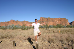
Returning home, we detoured through the ‘drive through’ Lesueur National Park. We have now seen many wildflowers along our travelling route, however the wildflowers in is park where pretty special. The park actually contains 10% of WA’s flora, including plants found nowhere else in the world.
Lesueur National Park

Sweeping valleys of shrubs and flowers are enclosed by a ring of hills and plateau’s, segregating the plants from beyond.
But it was Nambung National Park that had the wackiest feature. The Pinnacles- limestone pillars rising like gnarled fingers grasping for air out of the yellow sand dunes. Scientists are not really sure how they formed and the mystery of these thousands of structures may never be solved. We had both heard of the Pinnacles, but were shocked to see how many there were and how yellow the sand, given the surrounding white sand dunes.

The Pinnacles

The weird and wacky delights continued with a viewing of more stromatolites and their cousins- the thrombolites. Were stromatolites grow in layers, thrombolites grow in clusters. They all end up looking pretty much the same though- like lumps of rock.

Stromatolite and Thrombolite

Things are not always as they seem though- the lumps of wood lying on the road were actually Bob Tailed Skinks, there were so many of them, we were constantly dodging these slow lizards so as not to run over them. Some we had to stop to move out of the way, although they were not always agreeable to being moved off the warm road.

Bob Tailed Skink- not happy about being moved out of the way

As we head south, to the bottom of WA, we have truly left the outback behind. Although we still peer out of the window to endless countryside, it is no longer the wild Australian bush. We have now entered the ‘country’ with her man made fields, chopped trees and livestock. Our drive south, was a big one covering nearly 500 kilometres in one day. Weary and in need of a warm shower, we decided to stopover at Kojonup for the night. The brisk evening added to the Blue Mountains feel of this town, but 1970’s style buildings and plentiful sheep had us elsewhere.
Refreshed it was onto Albany. Now at the southern most point of WA, the coast is broken up into many bays with granite islands rising out of the sea. It is a spectacular coastline and was the last sight for many Australian soldiers who were to die at Gallipoli.

View across to ANZAC monument and out to sea

Albany is actually the town where the first dawn service was held in 1918, now a tradition of every ANZAC day. Mt Clarence, rising majestically above the town, was where the people of Albany gathered in 1914 to watch the convoy of ships destined for Egypt. The soldiers were then trained there before landing at Gallipoli. Now it hosts a monument to those who will never return to the harbour and a poignant spot, reflecting the ANZAC spirit.
Albany and her surrounds are full of natural beauty, including Little Beach. Finally, I had found a great beach.


Little Beach, Albany


The water was so clear and blue it looked like a jelly slowly wobbling, as the waves lapped the shore. Alas, the weather was not commensurate to my beach ideal. So, it was off to admire the coastal cliffs. With surging seas straight from Antarctica, the huge granite boulders of the coastline have been weathered into many interesting formations.

Natural bridge formation, Albany coast

A wind farm takes advantage of the weather here, the turbines towering above the mesmerising granite strewn landscape. The granite strewn Albany coastline

Sunday, October 18, 2009

WOW WEE

West Australia is huge with vast uninhabited areas of ‘nothing’ spreading across her belly. Distances between towns cover many miles. It is much like the landscape of Central Australia; only the sea is ever present, offering some cool relief.

We pulled off the road to let this one pass

Mining is expanding the remote towns, but infrastructure has to be trucked, on oversized trucks, from far afield. With only a narrow two lane highway, it is easier to pull off onto the verge to let these oversize trucks pass.
However, upon arrival at the World Heritage Shark Bay area, the sights on offer assured us the journey has been well worth it. Hamelin Pool, makes the mind boggle. This is one of the few places in the world, where you can view Stromatolites. Stromatolites are literally the first life forms on earth. Made of cyanobacteria, they lived alone on earth for 3.5 billion years, happily growing ever so slowly in the hyper saline waters, at a time when oxygen was scarce.

Stromatolites!

As the stromatolite colonies expanded they released more oxygen, raising the level to 20% of all atmospheric gases. This led the way for breathing life forms to evolve and ultimately us! Without these rock like formations, we would never have existed. WOW.

They look just like rocks in the water....

Over 60 years have passed since Hamelin Pool housed a jetty to load wool onto awaiting dinghies. Back then the importance of these ‘rocks’ was not known, and growing at a rate of only 1cm every 30 years, the camel wagon tracks can still be clearly seen criss-crossing the Stromatolite formations.

Camel wagon tracks in the Stromatolites

The Shark Bay World Heritage area has many world exclusives. Although similar fish species are found in other waters, many, like the Pink Snapper, have adapted to the hyper saline waters, making them unique to this area. The tiny Cardiid Cockle is also only found here. Waves constantly wash these shells ashore in such large quantities that Shell Beach, is quite literally solely made up of these tiny shells. Dig down 10 metres and you will still only find shell! Having being washed ashore for the last 6000 years, they cover a decent amount of area. Small quantities of calcium carbonate within the shells dissolve in rainwater and then dry to become a white crystal, which binds them together. The resulting soft limestone is called coquina.

Shell Beach


Coquina Shell quarry

This coquina has been quarried to construct buildings in the town of Denham- Australia’s most westerly town. A very pretty little town, with friendly locals, the caravan park even had its own mascot- a huge Newfoundland dog!
Francois Peron National Park also lies within the Shark Bay World Heritage area and many features within the park contributed to the World Heritage listing. Offering views of the coastline out to sea, you can see dugongs, dolphins, turtles and rays. Unfortunately on the day of our visit only the rays were on show. The land based critters proved to be more prolific. Having followed a goanna track, we were soon eye to eye with him. It was nearing lunchtime, so I guess it was acceptable that he had caught a small furry ‘thing’ and was slowly devouring him live.


Goanna has some lunch

Poor little critter.... We walked along the rust red sandy cliff top, which reached down to the white sand beach and out to the aqua blue sea, making the whole scene a spectacular sight.

Red cliffs lead to a white sandy beach and aqua waters in the National Park

The national park was actually once a pastoral station, with the homestead now a visitor’s centre. The original artesian bore, which had been made into a hot tub, has been maintained and was great for a soak in after our long walk. The water is a constant 44 degrees, so we did not stay in for too long though.

Relaxing in the hot tub

It was well worth the drive out here, even though the red sandy track was very soft in sections up and over sand dunes and tested Dave’s 4WD skills.

But, the most famous attraction of this area is Monkey Mia. Setting the alarm, Dave and I awoke early to be ready for the 7.30am ‘feeding of the dolphins’. As we walked down the beach, we were accompanied by a couple of dolphins, leading us to the interaction area. Standing ankle deep at the water’s edge, the dolphins swam in close to check us out.

Dolphins popping over to check us out

Even the calves swam up to our feet under the watchful eye of Mum. These dolphins are Indo-Pacific Bottlenose Dolphins- smaller and cuter than the Common Bottlenose Dolphin. After half an hour of playtime, buckets of fish were brought down. Only 5 dolphins are fed, and if those five don’t turn up, there is no feeding. We didn’t realise how lucky we were to have all the feeding dolphins and an additional eight turn up, until the next day, when only two were on hand. To ensure the dolphins’ still hunt in the wild only a small amount is offered. This means only a handful of people from the audience are chosen to ‘give a fish’. I was very fortunate to be selected and fed a dolphin named Surprise!

Me feeding Surprise!!

Monkey Mia is a very pretty spot, and I could have sat under the palm tree watching the dolphins frolic all day.

It is not just the dolphins who enjoy excellent fishing in these waters. Our neighbour, a regular at Monkey Mia, took his boat out fishing daily and supplied us with Mackerel, which he filleted and Blue Swimmer Crabs. Confirming that we both liked Chilli, he even cooked them for us!
Alas, with more of this World Heritage area to see, it was time to say goodbye to our dolphin friends.

The most westerly point of Australia!

Steep Point has the claim of being the most westerly point of Australia. Having been to the most easterly and southern, it was a photo we had to have. We were told the road out was 4WD only, covering sand dunes and a rough track. We were quite happy to discover the road in good repair, with only one hair raising steep sand dune. In fact, we really enjoyed the 180 kilometre trip out to Steep Point. What we hadn’t been told was how breathtakingly beautiful the journey would be. The colour of the water, the virgin sand dunes, and the collage of different coloured bushes left us with a lump in your throat feeling. This pristine wilderness will become the Edel Land National Park in the future and well worth a visit. Being a narrow point, we had beaches on one side and cliffs on the other. The Zuytdorp Cliffs tower 170 metres above the water, however the waves below crashing were sending spray almost to the top!
Water shooting up the Zuytdorp Cliff illustrates why "King Waves Kill"


The Shark Bay World Heritage Area is our favourite destination to date. Alas, after a week exploring her delights we were on the road again. We (finally) left the Outback Coast and watched the scenery became increasingly lush until a path of wildflowers lined the highway to Kalbarri.